

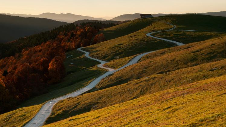
The Three-Borders Ring is a picturesque trail winding through the southeastern area of the Altopiano, along the edge overlooking the plain and the Brenta valley. It's a green walk, full of charm, connecting the mountainous territories of Campolongo, Conco, Valstagna, and, for a few dozen meters, even Bassano del Grappa. The route spans nearly 20 kilometers through woods, trails, and dirt roads, allowing hikers to reach alpine dairies, historic sites, and scenic viewpoints. The trail, which has an elevation gain of 600 meters, takes about 6 hours to complete, but it can also be divided into shorter sections, using the many roads built during World War I for the return journey. The loop can be accessed at various points, but the suggestion is to hike it counterclockwise, starting from Val Lastaro in the municipality of Lusiana Conco, where there is a convenient parking area. Just a few meters from the start, you can visit the Paleolithic site where traces of human presence and flint processing dating back 13,000 years have been found. The trail then continues uphill through meadows towards Mount Frolla, which offers a vast panorama of the Venetian plain: on clear days, the view can extend all the way to the Apennines and Istria. Continuing along the path, you pass by the agriturismo Le Porte on Mount Cogolin, then reach Colle Zolina; at this point, you can take the paved road on the left that leads back down to Val Lastaro passing by Malga Verde. If instead you continue straight, you will face the ascent towards Pian de la Casaretta, nestled among beech forests, with its namesake alpine hut. Walking along the path that passes among the alpine huts, after a few hundred meters, you join the CAI trail number 800, which you follow to Malga Pozzette, strolling among small bodies of water, meadows, and expansive views, now in the municipality of Valstagna. The valley is rich in water and has always been sought after for grazing. Here, rising from the valley floor near Oliero, is an ancient cattle track, partly resembling the Calà del Sasso staircase. The area was once known as a transit point for tobacco smugglers, with terraced fields still visible from that time. Once here, you can follow the original route that ascends to Col d'Astiago, or you can shorten the hike and quickly reach Vasca del Termine Rotto by following the road towards the alpine hut. If you decide to complete the full loop of the Three Borders, you'll reach Col d'Astiago, an important Italian defensive stronghold during World War I. Locally, it's also called Col del S'ciavo because the Republic of Venice used Slavic (Schiavoni) laborers to cut the timber needed for building the ships of the Serenissima. The logs were then dragged along the Calà del Sasso to the Brenta River, where they were tied into rafts and floated down to Venice. Col d'Astiago is an exceptional viewpoint where you can admire the Brenta Canal, the Pale di San Martino, the Feltrine Peaks, and the massive Grappa Mountain Range. From there, you descend passing through Malga Col de Novanta down to Vasca del Termine Rotto, built to provide water for the Italian troops' mules during World War I. This basin is still visible at the roadside junction. From here, you can return to Bosco Littorio and Val Lastaro by descending along the Biancoia road, or alternatively, passing through Cima Malcroba and Colle Zolina. Continuing along the loop, you reach Col Cagnon by passing through the viewpoint at Campaniletto on Cima Montagnanova and Malga Montagnanova Dadrio, with views over the Altopiano and the battlegrounds of the three mountains (Val Bella, Col d'Ecchele, and Col del Rosso). From Col Cagnon, you can perceive the vastness of the "bosco nero" (black forest) that covers the entire southern chain of the Altopiano. Returning to the starting point passing by Malga Montagnanova Davanti, shortly after, you encounter a centuries-old beech tree that has witnessed two world wars. Beyond the intersection towards Val Biancoia and Bosco Littorio, planted in 1927 to repair the damages of war, you find yourself back in Val Lastaro.
(GdV, domenica 7 aprile)