

Easy hike to the top of Campo Mandriolo crossing one of the most pristine areas of the Altopiano dei Sette Comuni, which offers a panorama of the Dolomites extending all the way to the Venice Lagoon. The trail is in the Larici locality, on the border between Veneto and Trentino, or more correctly between the territory of the Sette Comuni plateau and Levico Terme, so much so that the two lakes of Levico and Caldonazzo extend right below the belvedere that will be reached. A particularly pleasant outing in this period with the abundant snow that has fallen and the clear skies that winter can give. The route unfolds in a succession of small climbs and descents that make the outing challenging and not boring. It starts from the parking lots of one of the two shelters in the area, rifugio Valformica or rifugio Larici "Da Alessio." From the hairpin bend that leads to the forecourt of the “Da Alessio” hut, start out on foot, or at this time with snowshoes, along the small road that leads into the woods and pastures. The path is well visible, so no special directions are needed. After about a kilometer the road begins to climb, but gently, and does not require much effort. In addition, the forest moves away from the road, leaving the hiker immersed in a wide expanse, green in summer and now snow-white. Continue by following the path formed by the flat road running between the slope on the right and the descent on the left. After about a kilometer and a half you meet the first observatory, Porta Manazzo, which can be reached by detouring from the main route for about a hundred meters. From here you can already see the first Dolomite peaks and below the Valsugana or looking further on Mount Cola, cima d'Ezze and turning your gaze eastward the Pale di San Martino.
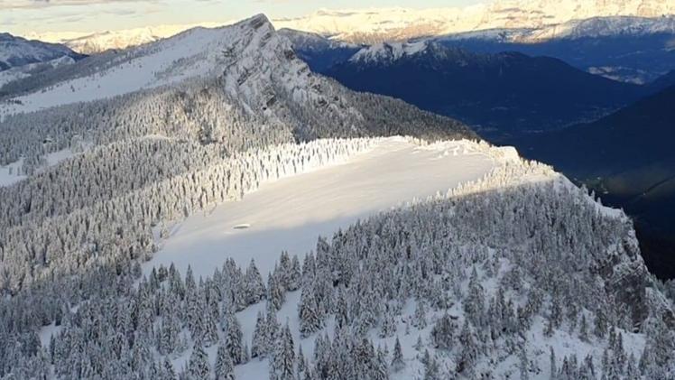
Back on the main route, continue west, leaving the Porta Manazzo hut on the left, and continue for another two kilometers or so until you meet a small road marked with a prohibition on the right. This also indicates the point where you leave the main road and ascend this trail, at first narrow among firs, larches and mountain pine then, after 6-700 meters, opening onto the pastures of the Campo Mandriolo bottoms. At that point you continue straight uphill, on the only really challenging slope, to the ridge located at an altitude of 1,950 meters. From this point, begins the only section where great care must be taken. The ridge comes suddenly and, in case of abundant snow, this may give way under the weight of the hiker, or in windy periods the snow may form an icy edge, giving the impression of being on the ridge when one is already beyond the mountain's edge. From the ridge, or rather from a few meters below, one can reach the Mandriolo peak with a strenuous ascent that will be rewarded, however, by the 360-degree panorama. To the west, against the sky, stands out Spitz Verle, with the remnants of the Austro-Hungarian fort still marking its summit. To the north, a succession of Dolomite peaks extends all the way to the Swiss Alps. To the east, one can see the peaks of Larici and Portule, along with the entire ridge marking the border between Veneto and Trentino, and to the south, you can admire Mount Verena. Below, one can observe the deep valleys carved into the rock by millennia of ice and water, reaching down to the valley floor of Valsugana. For the return journey, follow the same route as on the way there. Alternatively, if desired, one could descend below the road and reach Valformica through forests of fir and larch, but caution must be exercised to avoid ending up on the ski slopes of the homonymous ski resort.
In all, the trail takest took about 4 hours, enough to whet the appetite, which can be satisfied in one of the two refuges open year-round; if, on the other hand, the route is taken in summer, there is plethora of options to choose from among the many huts in the refreshment area. As always, appropriate clothing is necessary with boots, windbreaker, and winter pants in addition to gloves, cap, some hot tea and a change of clothes for when you return. Also useful are sunglasses, sunscreen, and a headlamp.
(GdV, domenica 2 aprile)