

A walk whose heart is the "Seven Roccoli Trail." The departure for the hike that follows the ridge between Valdagno, Schio and Monte di Malo is highly variable since the trail touches as many as three municipalities. In addition to different lengths, and thus more or less physical commitment, one can choose between paved but little-traveled stretches or instead follow the forest trails, where the terrain also requires hiking footwear. Clearly, the choice also depends on the available time.
From Passo Zovo
Here you can opt for the longer route and leave your car at the Zovo Pass, where to the right of the restaurant you will take a wide, slightly uphill path that skirts the dirt parking lot, where a sign reminds you that you are walking along "Orthogonal 1," or the Great War defensive line that from Campogrosso ended at the Vicenza entrenched camp and that you will also follow with this walk on the watershed ridge between the Agno and Leogra valleys. Soon the trail becomes almost flat and then gives way to the descent and then to ups and downs that will accompany the hiker to the Mucchione Pass, from where the "Seven Roccoli Trail" actually starts. But one can also take the asphalt road, through woods and meadows, which also leads effortlessly to the "Mucion" location. In any case, the distance is about three and a half kilometers and the time required is about 45 minutes.
The ’Mucchione’
And here is the natural start of the trail that winds along a path that sees the succession of the ancient hunting posts that were once used to catch decoy birds. Right at ’Mucchione’ you can leave your car in the parking lot below the clearing where the small church and restaurant of the same name stand. But before embarking on the walk, it is worth taking a look at the beutiful little church of ’Mucchione’, built in 1954, where every August 15 the Madonna Assunta is celebrated with a local festival. Built in alpine style with a sloping roof and the facade embellished with a rose window, the building on the apex of the roof houses a wrought-iron cross. The name of the locality derives from the presence of two mountains of volcanic origin with a typical cone shape (’mucio’ in Venetian), placed as sentinels guarding the municipalities of Schio and Valdagno. At this point you just have to continue walking eastward along the "Sentiero dei Roccoli" that leads into the territory of Monte di Malo. The path through the woods is not particularly challenging, but it has descents and ascents that are a bit steep in places and leads to Passo Cima in just over an hour. The origin of the cluster of buildings, not far from the Valdagnese border, is traced back to the settlement of the Cimbrian people. The trail, from Mucchione to contrada Cima, is three kilometers that you travel at an altitude of about 650 meters. You cross an area characterized by volcanic rock, where you pass short conical hillocks on which chestnut trees appear. This area is traversed by a Neolithic track, which starts from San Tomio di Schio and leads to the Valdagnese hamlet of Novale and is evidenced by the discovery of various artifacts, a Cimbrian passage dating back to the Middle Ages and evidenced by the names of the districts that rise around the "Trail of the Seven Roccoli" and a Route des Imperiaux used in the period of the Holy Roman Empire.
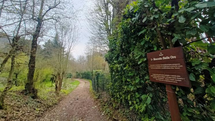
The roccoli
Starting from Mucchione, the first ’roccolo’ to be reached is the Crocco one, followed in the route by others usually employed in the past to catch birds that were going to be used ad live decoys in hunting: Dalle Ore, delle Tordine, Castellani, Bianco and, finally Sella. At the first crossroads keep right, uphill, passing the roccoli, the Ex Voto capital, and the Castellani fountain until you reach the Holy Family capital. Here walk a few meters to the left on the paved road to reach the destination: turn right and enter the Cima district. The return can be made by retracing the same route or by following the paved road.
(GdV, domenica 14 aprile)